Really interesting and surprising account on the Forest Hill Society website:
I find the Blitz mind-boggling, imagining the hardships and tragedy London endured. How well they did in the decades afterwards, to rebuild this city and make it such a global powerhouse.
There are parts of my garden where things won’t grow and the gardeners at Sydenham Community Garden say it’s because there is lingering heavy metals poisoning from shrapnel left by the Blitz. We’re close to Bell Green. The gasworks were a major target.
If you care to google it, there are a few projects mapping the bombings, including some interactive ones. I’ve also seen contemporary maps marking bomb strikes in our area, I’ll see if I can find the link.
Have long suspected that the flats on the corner of Devonshire/Boveney was a consequence of V weapon damage and, given the extent of the area, wondered if it was a V2. Fascinating to have confirmation that it was.
In Kilgour Road ( where I live) we had some houses bomb damaged at the end. My neighbour has a bug book showing every street in London that suffered bomb damage. I can ask him what it is called next time I see him if anyone is interested.
The post-war houses on Garthorne Road / Ewart Road replaced those destroyed by (I think) a V1 strike on Bovill Road. The 2nd floor of my Victorian house was rebuilt in 1945, according to the date inscribed in the loft timbers.
A visiting German friend once asked why the bricks were a different colour at the top. I merely cocked an eyebrow…
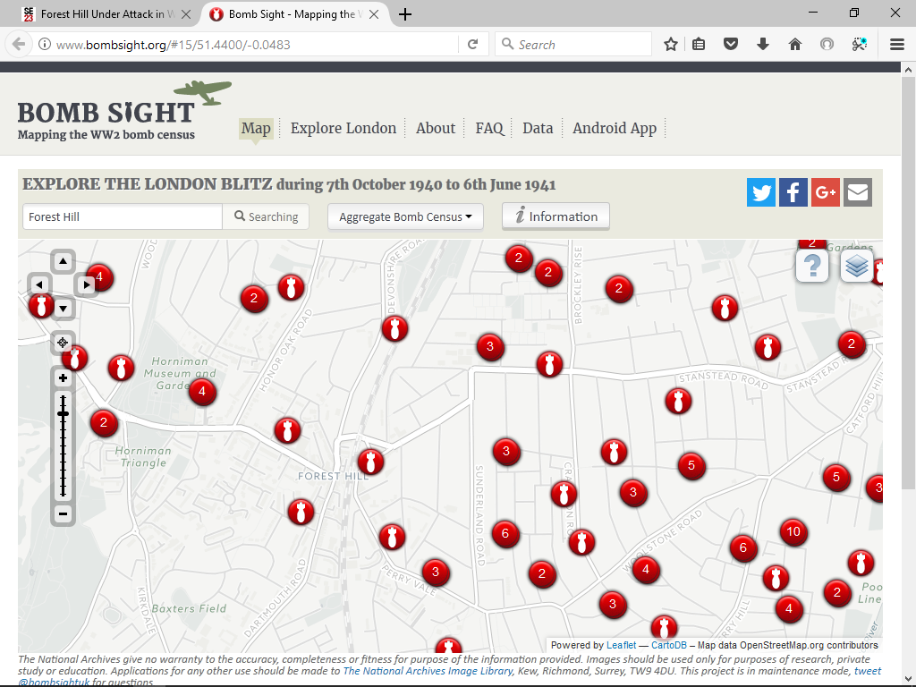
The maps show the Panmure Road V2 - it’s marked by a circle (large circles are V1s, smaller circles are V2s).
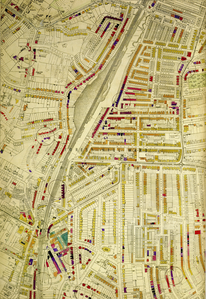
The book which shows all the bomb damage (and is where those Flickr photos are from) is the London County Council Bomb Damage Maps book. The first edition of it is incredibly expensive and hard to get hold of, but it was re-done about 2 years ago and you can get it from Amazon: https://www.amazon.co.uk/London-County-Council-Damage-1939-1945/dp/0500518254
It’s only streets within what was the LCC area, so Lewisham borough is covered but outer London boroughs aren’t, as they weren’t LCC. The maps are colour coded according to the grade of damage done, so lack is totally destroyed, purple damaged beyond repair, red badly damaged and I can’t remember the other colours. Brilliant resource!
Just in case you’re not aware of it, www.bombsight.org is an excellent resource for checking out what sort of ordnamce landed where during the Blitz… here’s a snapshot of the FH area
Ours on Sunderland Road has what looks like some newer brick work but from some time ago. We thought it might be bomb damage and the older map above suggests Sunderland Road homes may have some light bomb damage. So probably it! Cool. In a kind of not cool way.
Not connected to Forest Hill but interesting anyway. There was some media coverage last month about ‘stretcher railings’. Metal stretchers that had been used during the Blitz were re-purposed after the war as railings on housing estates, many in south London, and some are still in place.
We had a bomb shelter in our garden, Anderson style but made of concrete instead of metal. Caused almighty grief when trying to re-landscape the garden! Found some fascinating things lurking in the bottom of it, 1930s high heels, a old car steering wheel, very old tools in old wooden tool boxes, a microscope from 19th Century!
And Ebsworth Close at the bottom of Ebsworth Street is the result of a bomb which took down the victorian housing, so they replaced it with 1950s style.